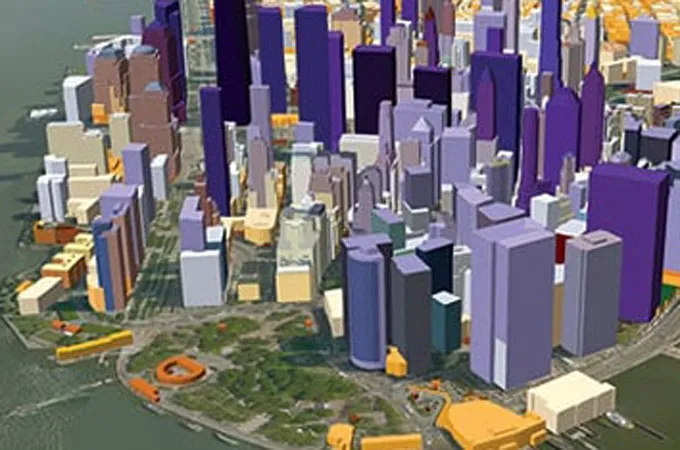
Scientists in Germany have, for the first time, produced the most comprehensive digital representation of the world’s built environment by compiling a high-resolution, three-dimensional dataset containing 2.75 billion buildings.
The GlobalBuildingAtlas, developed by a research team at the Technical University of Munich (TUM), provides a foundation for advanced climate studies and supports the implementation of the UN Sustainable Development Goals.
Xiaoxiang Zhu, PhD, a professor and holder of the Chair of Data Science in Earth Observation at TUM, who led the project, said the map is expected to enhance the accuracy of urbanisation, disaster management and infrastructure models, helping cities become more inclusive and resilient.
She explained that three-dimensional building data reveals patterns of urbanisation and poverty far more accurately than two-dimensional maps. "With 3D models, we see not only the footprint but also the volume of each building, enabling far more precise insights into living conditions," she stated.
Zhu noted that the map introduces a new metric called building volume per capita, a global indicator that measures total building mass per individual and highlights social and economic disparities. “This indicator supports sustainable urban development and helps cities become more inclusive and resilient,” she added.
The three-dimensional building data is expected to provide a precise basis for planning and monitoring urban development. It is also intended to help cities take targeted measures to create more inclusive and equitable living conditions, including the provision of additional housing or public facilities in densely populated, underserved areas.
The map is also considered vital for climate adaptation, as it improves models of energy demand, CO2 emissions and green infrastructure planning.
In addition, it strengthens disaster-prevention efforts by enabling quicker assessments of risks posed by natural events.